Viltnemnda: Norway’s Municipal Wildlife Committees and Positive Digital Transformation in 2026
Viltnemnda forms the backbone of practical, localized wildlife management across Norway. Each municipality operates or participates in its own viltnemnda — a committee that translates national wildlife laws into actionable decisions suited to local landscapes, communities, and ecological conditions.
From a technology and modern governance perspective, viltnemnda illustrates how traditional decentralized systems can integrate digital reporting and data tools to improve accuracy and efficiency without losing human oversight or local knowledge.
What Is Viltnemnda?
The term viltnemnda literally means “wildlife committee.” It refers to the municipal-level body responsible for day-to-day wildlife administration under Norway’s Wildlife Act (Viltloven).
Responsibilities typically include:
- Setting and adjusting local hunting quotas within national guidelines
- Processing hunting permits and regulating harvest of species such as moose (elg), roe deer, red deer, and beaver
- Addressing human-wildlife conflicts, including crop and forest damage or traffic safety issues
- Allocating resources from the national wildlife fund
- Contributing local insights to broader population monitoring
This decentralized approach allows committees to account for regional differences — dense forests and agricultural areas in the south versus mountainous or coastal regions further north. National oversight comes primarily from the Norwegian Agriculture Agency (Landbruksdirektoratet) for harvestable game species and the Norwegian Environment Agency (Miljødirektoratet) for broader nature management and biodiversity.
How Viltnemnda Works in Daily Practice
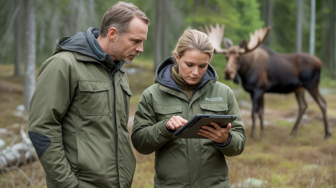
Committees usually comprise locally appointed members with relevant experience, such as hunters, landowners, biologists, or municipal officers. They review available data, consult stakeholders, propose quotas, handle permit applications, and respond to reported incidents.
Hunters must report harvested animals, and landowners can notify the committee about damage or problematic wildlife. Decisions aim to balance sustainable use, population health, economic interests (farming, forestry, tourism), and public safety.
Core challenges addressed by viltnemnda include preventing over- or under-harvesting, minimizing road collisions with large game, and reducing conflicts between wildlife and human land use — all while operating within a framework that values both scientific input and local expertise.
Current Digital Tools Supporting Viltnemnda
Norway’s high digital maturity enables incremental improvements in wildlife data handling. The most tangible example is the Viltdata mobile app, developed in cooperation with hunting organizations. Hunters and teams use it to report harvested game directly from the field. The data feeds into official statistics, helping committees and national authorities track harvest levels more reliably and quickly than older paper-based methods.
Other practical digital supports include:
- Online portals for permit applications and damage reporting
- GIS mapping tools for visualizing habitats, conflict hotspots, and hunting zones
- Access to national wildlife databases for aggregated statistics
- The Fallvilt app, used by authorized personnel to register roadkill and fallen game
These tools primarily enhance data timeliness and consistency. For instance, immediate digital reporting reduces gaps or delays that once affected annual statistics. Some municipalities and research partners also use camera traps or limited GPS collaring in targeted studies, often coordinated with institutions like NINA (Norwegian Institute for Nature Research).
However, widespread deployment of advanced sensors remains limited by cost, harsh weather, remote terrain, and the need to maintain public trust.
Technology Overview: Practical vs. Emerging Uses
In active use today:
- Mobile harvest reporting (Viltdata)
- Digital submission of observations and damage claims
- Basic GIS for local planning
- Centralized national registers that municipalities can query
Emerging or research-level applications:
- Camera traps for non-invasive monitoring
- Selective GPS tracking in scientific projects to understand movement patterns
- Drones for limited surveys in accessible or high-priority areas
Claims of fully automated AI decision-making or comprehensive “digital twins” for every municipality are not yet operational realities in standard viltnemnda work. Instead, technology serves as a supportive layer: it supplies better evidence, while committees retain responsibility for contextual judgment and democratic input.
One documented direction involves using movement data from collared animals to inform road safety measures, such as adjusting signage or fencing in high-risk zones.
Benefits of Digital Support for Viltnemnda
When applied pragmatically, these tools deliver clear advantages:
- Higher data quality — Real-time or near-real-time reporting improves the accuracy of harvest and population trend information.
- Faster response — Committees can identify emerging conflict patterns (e.g., repeated crop damage in a specific valley) more quickly.
- Reduced paperwork — Online systems free administrative time for field engagement or stakeholder dialogue.
- Greater transparency — Digital records make processes easier to audit and explain to the public.
- Better-informed local decisions — Access to mapped data helps tailor measures to actual conditions rather than broad assumptions.
For technology developers, this opens opportunities in creating rugged, user-friendly field apps, offline-capable tools for remote areas, and simple analytics dashboards that respect Norwegian data protection standards and local autonomy.
Limitations and Practical Challenges
Digital integration is not without hurdles:
- Infrastructure gaps — Many rural and mountainous municipalities face connectivity issues; equipment must endure extreme cold, snow, and moisture.
- Resource differences — Larger or wealthier municipalities can adopt tools faster than smaller ones.
- Data still relies on humans — Apps help structure input, but accurate species identification, ethical reporting, and understanding of local nuances remain critical.
- Cost and ethics — Extensive GPS collaring or drone programs require funding and raise questions about disturbance to animals.
- Risk of over-reliance — Technology should complement, not override, traditional ecological knowledge held by experienced hunters and landowners.
Viltnemnda decisions ultimately stay human-led and subject to legal and community accountability.
Comparison: Traditional vs. Digitally Supported Viltnemnda
| Aspect | Traditional Approach | Digitally Supported Approach |
|---|---|---|
| Harvest Reporting | Paper forms, potential delays | Mobile apps (e.g., Viltdata) with immediate upload |
| Monitoring | Hunter observations, occasional counts | Combined with national data, camera traps, GIS |
| Permit & Damage Handling | Manual processing | Online applications and digital tracking |
| Conflict Identification | Reactive after incidents | Earlier pattern detection from logged data |
| Transparency | Limited real-time insight | Improved auditability through digital records |
This evolution emphasizes evidence-based local management while preserving flexibility.
Who Should Engage with Viltnemnda?
- Hunters and hunting teams — Primary users of reporting tools like Viltdata.
- Landowners and farmers — For reporting damage and requesting preventive measures.
- Municipal officials and committee members — For administration and quota setting.
- Researchers and conservation groups — Contributing to or accessing datasets via official channels.
- Residents — Reporting wildlife observations or safety concerns through their local kommune.
International observers interested in decentralized environmental governance can study Norway’s model for balancing local authority with national standards and selective digital support.
Future Outlook for Viltnemnda and Technology
Reasonable near-term developments include:
- Broader standardization of digital reporting across all municipalities
- Improved interoperability between local systems and national databases
- Selective expansion of remote sensing where it offers clear cost-benefit advantages
- Tools that help committees incorporate climate-related shifts, such as changing migration patterns
The most valuable innovations will likely be practical: reliable offline functionality, intuitive interfaces for non-technical users, and solutions that strengthen — rather than sideline — local knowledge and stakeholder trust.
Overly ambitious “smart ecosystem” concepts risk distraction from the core goal: delivering timely, trustworthy data that supports sound, context-aware decisions.
FAQ About Viltnemnda
What is viltnemnda? Viltnemnda is the municipal wildlife committee in Norway. It handles local implementation of hunting regulations, quota decisions, conflict resolution, and sustainable wildlife management.
How does viltnemnda incorporate digital tools today? Committees use the Viltdata app for harvest reporting, online permit systems, GIS mapping, and access to national wildlife registers. These tools improve data flow and efficiency while committees retain final decision-making authority.
Is viltnemnda fully automated? No. Digital tools support data collection and administration. Human committees evaluate information, incorporate local context, and make balanced decisions according to law and community needs.
Who should contact viltnemnda? Hunters for permits and reporting, landowners affected by wildlife damage, and residents with wildlife-related concerns. Contact your local municipality (kommune) for specific procedures.
What problems does viltnemnda solve? It enables locally adapted management of wildlife populations, reduces human-wildlife conflicts, supports sustainable hunting traditions, and helps protect both biodiversity and rural economies.
Are there misconceptions about viltnemnda and technology? Yes. Some assume it is either purely bureaucratic or rapidly becoming fully AI-driven. In practice, it remains a human-centered local system that uses digital tools selectively to strengthen evidence-based decisions.
What are realistic future developments for viltnemnda? Further standardization of digital reporting, better data integration across government levels, and targeted use of monitoring technologies where they deliver practical, reliable benefits in Norwegian conditions.
Conclusion: Viltnemnda as a Model of Balanced Modernization
Viltnemnda demonstrates how decentralized governance can evolve thoughtfully with technology. By focusing on practical digital supports — such as mobile reporting apps and mapping tools — Norway’s municipal wildlife committees can access better data while preserving local knowledge, democratic input, and adaptability to diverse landscapes.
For technology professionals, policymakers, and conservation innovators, viltnemnda highlights the value of user-centered, context-aware solutions over flashy automation. The strongest advances will be those that are robust in harsh environments, affordable across municipalities, and designed to augment human expertise rather than replace it.
If you are involved in hunting, land management, municipal governance, or environmental tech in Norway or similar regions, the best next step is to consult your local kommune and official resources from the Norwegian Agriculture Agency or Environment Agency for the most current guidelines and tools.


Post Comment